


Tropical Storm ONE expected to cause heavy rains and strong winds in northern regions of Puntland and Somaliland A tropical storm named ONE has been developing in the northern Indian Ocean and is expected to affect most parts of northern regions in Somaliland and Puntland in the next 24 to 48 hours.
The storm is expected to affect coastal areas of Puntland in the next 24hours and spread further inland towards Somaliland and the central areas with time. Strong winds with heavy rains will therefore be experienced in areas situated along the storm path. Therefore, it is advisable to take the necessary precautions since the strong winds associated with the tropical storm might lead to destruction of weak structures. Flash floods are also foreseen in these areas.
SWALIM and partners are monitoring the situation and will update you accordingly. For more details on tropical storm tracking you can consult: http://www.tropicalstormrisk.com/ or consult SWALIM.
![]()
RELATED COVERAGE:
Rare Gulf of Aden Tropical Cyclone Sagar Could Bring Life-Threatening Flooding to Yemen, Somalia, Djibouti
Story Highlights
A tropical cyclone, Sagar, has formed in the Gulf of Aden between Yemen and Somalia.
Sagar’s main threat is dangerous flash flooding in the deserts of southern Yemen, northern Somalia and Djibouti.
Tropical cyclones moving from the Arabian Sea into the Gulf of Aden aren’t rare.
Cyclone Sagar developed late Wednesday in the Gulf of Aden between Yemen and Somalia, and could become one of the first tropical storms on record to cross the entire Gulf of Aden—perhaps affecting even the tiny nation of Djibouti, where tropical cyclones are virtually unknown.
(MORE: Hurricane Central)
Tropical Depression 1A was named Cyclonic Storm Sagar by the Indian Meteorological Department, the agency with primary responsibility for tropical cyclone forecasting in the North Indian Ocean, including the Arabian Sea.
As of Thursday evening, local time (Yemen is 7 hours ahead of U.S. EDT), Sagar is a small, compact tropical cyclone with winds estimated at tropical storm force, according to both the Indian Meteorological Department and the U.S. Joint Typhoon Warning Center.
Showers and thunderstorms pinwheeling around Sagar’s compact core were moving onto the Yemeni coast Thursday, while a cluster of intense thunderstorms well southeast of Sagar was affecting northeast Somalia (see image above).

Current Information, Infrared Satellite
The highest cloud tops, corresponding to the most vigorous convection, are shown in the brightest red colors in this infrared satellite image. Clustering, deep convection around the center is a sign of a healthy tropical cyclone. (Storm status: JTWC)
Sagar has been gaining some strength, according to satellite intensity estimates, taking advantage of a favorable environment of low wind shear and water temperatures at least 30 degrees Celsius (86 degrees Fahrenheit).
The main threat from Sagar will be heavy rainfall, with parts of the Yemeni coast, Somalia and Djibouti potentially picking up 2 to 5 inches of rain.
These are substantial totals in desert environments that don’t typically get much moisture, and where the rugged landscape is prone to flash flooding. For instance, the average yearly rainfall in Djibouti City is only around 6.4 inches (163.5 millimeters)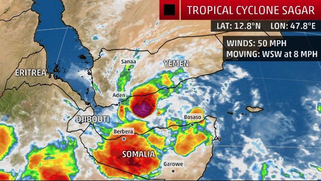
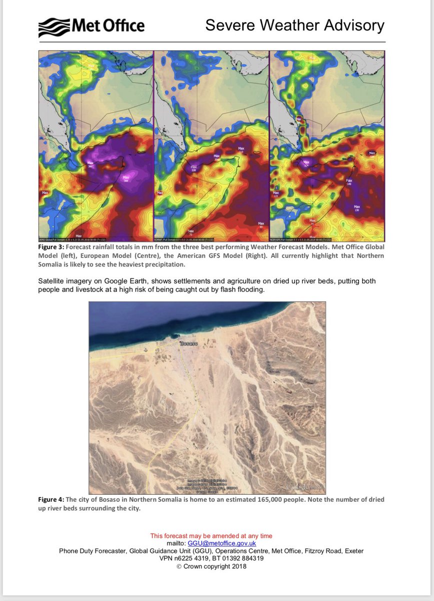
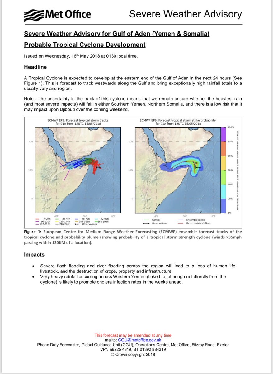
In a special advisory issued Wednesday and posted by reliefweb.org, the UK Met Office warns that “severe flash flooding and river flooding across the region will lead to a loss of human life, livestock, and the destruction of crops, property and infrastructure.” The Met Office added: “Very heavy rainfall occurring across Western Yemen (linked to, although not directly from the cyclone) is likely to promote cholera infection rates in the weeks ahead.”
A Rare Track?
If Cyclone Sagar’s core can avoid tracking too close or over land, it may make a full trip across the western Gulf of Aden by Saturday, possibly moving ashore in either northwest Somalia or Djibouti, according to the Joint Typhoon Warning Center.
This full Gulf of Aden track would be exceedingly rare.
Since satellite surveillance of tropical cyclones began in 1966, only two tropical cyclones have moved into the western Gulf of Aden.
Cyclone Megh, the second of back-to-back tropical cyclones that hammered Socotra Island, east of Somalia, made landfall along the Yemeni coast in November 2015.
Tropical Storm 1A traversed almost the entire Gulf of Aden before landfalling in northwest Somalia on May 28, 1984.
Only two tropical cyclones have tracked into the western Gulf of Aden in historical record dating to 1966. (NOAA Historical Hurricane Tracks)
Tropical cyclones are most common in the Arabian Sea in spring and autumn, during the transition periods between the strong southwest flow of the summer monsoon and the strong northeast flow that predominates in winter.
On average, the Arabian Peninsula is affected by a tropical cyclone every year or two.


")

